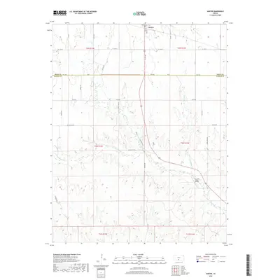
2018 Map of Sawyer
USGS Topo · Published 2018About this map
The town of Sawyer serves as the primary focal point of this rural landscape where the High Plains transition between Pratt and Barber Counties. The hydrology is dominated by a complex network of drainage systems, including N Elm Cr, S Elm Cr, and Crooked Cr, which converge as they flow toward the southeast. These waterways have historically dictated the placement of local infrastructure, such as Nw Elm Mills Rd, suggesting a legacy of milling or water-resource management in this agricultural region.
Find a feature on this map
37 named features on this map. Tap any name to fly to it.
Don’t see what you’re looking for? This feature index may not catch every label — zoom into the map to look around manually.
Map Details
Editions of this 2018 Sawyer Map
This is the sole edition of this map. No revisions or reprints were ever made.
Other maps of this area

1891 · Medicine Lodge
USGS Topo · 1:125,000

1892 · Pratt
USGS Topo · 1:125,000

1893 · Medicine Lodge
USGS Topo · 1:125,000

1894 · Pratt
USGS Topo · 1:125,000

1955 · Pratt
USGS Topo · 1:250,000

1959 · Pratt
USGS Topo · 1:250,000

1968 · Pratt SW
USGS Topo · 1:24,000

1968 · Coats
USGS Topo · 1:24,000
1968 · Pratt SE
USGS Topo · 1:24,000
1973 · Sun City NE
USGS Topo · 1:24,000