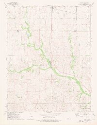
1973 Map of Sawyer
USGS Topo · Published 1975About this map
The town of Sawyer serves as the primary hub in this southern Kansas landscape, situated along the Atchison Topeka and Santa Fe railroad line. The map reveals a land defined by its waterways, most notably where North Elm Creek and South Elm Creek converge to form the main branch of Elm Creek. To the south, the settlement of Elm Mills sits near the creek's edge, while the surrounding hills are dotted with numerous Oil Wells and Gas Wells, signaling the region's energy production in the early 1970s.
Find a feature on this map
22 named features on this map. Tap any name to fly to it.
Don’t see what you’re looking for? This feature index may not catch every label — zoom into the map to look around manually.
Map Details
Editions of this 1973 Sawyer Map
This is the sole edition of this map. No revisions or reprints were ever made.
Other maps of this area

1891 · Medicine Lodge
USGS Topo · 1:125,000

1892 · Pratt
USGS Topo · 1:125,000

1893 · Medicine Lodge
USGS Topo · 1:125,000

1894 · Pratt
USGS Topo · 1:125,000

1955 · Pratt
USGS Topo · 1:250,000

1959 · Pratt
USGS Topo · 1:250,000

1968 · Pratt SW
USGS Topo · 1:24,000

1968 · Coats
USGS Topo · 1:24,000
1968 · Pratt SE
USGS Topo · 1:24,000
1973 · Sun City NE
USGS Topo · 1:24,000