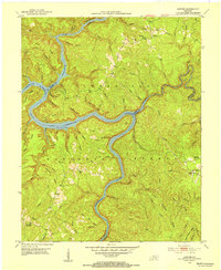
1952 Map of Sawyer
USGS Topo · Published 1954About this map
The Rockcastle River and Laurel River converge within the heart of the Cumberland National Forest, carving deep valleys through the plateau in this 1952 topographic study. This era captures a landscape of dispersed rural settlements where life centered around small country schools and community churches. Points of interest for local historians include the tiny hamlet of Sawyer and the community at Baldrock, each supported by nearby institutions such as Poynters Sch and Sawyer Sch. The mapping of the Cumberland River section reflects the geography prior to significant modern shoreline alterations, showing the original river course and its numerous named tributaries like No Business Branch and Bark Camp Creek. Genealogists will find value in the placement of local landmarks like the Hamilton Cem and Young Chapel Cem.
Find a feature on this map
73 named features on this map. Tap any name to fly to it.
Don’t see what you’re looking for? This feature index may not catch every label — zoom into the map to look around manually.
Map Details
Editions of this 1952 Sawyer Map
2 editions found
Other maps of this area

1890 · Williamsburg
USGS Topo · 1:125,000

1893 · London
USGS Topo · 1:125,000

1894 · Williamsburg
USGS Topo · 1:125,000

1897 · London
USGS Topo · 1:125,000

1952 · Wofford
USGS Topo · 1:24,000

1952 · Hail
USGS Topo · 1:24,000

1952 · London SW
USGS Topo · 1:24,000

1952 · Vox
USGS Topo · 1:24,000

1952 · Ano
USGS Topo · 1:24,000

1952 · Wiborg
USGS Topo · 1:24,000