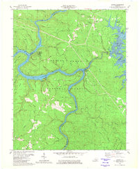
1980 Map of Sawyer
USGS Topo · Published 1981About this map
The Rockcastle River and Laurel River converge here, carving through the Daniel Boone National Forest to form the expansive reaches of Cumberland Lake. This 1980 survey captures the region after the creation of Laurel River Lake in the northeast, showing the transformation of the landscape into a recreational hub with numerous sites like the Holly Bay Boat Ramp and Craig Creek Campground.
Find a feature on this map
84 named features on this map. Tap any name to fly to it.
Don’t see what you’re looking for? This feature index may not catch every label — zoom into the map to look around manually.
Map Details
Editions of this 1980 Sawyer Map
2 editions found
Other maps of this area

1890 · Williamsburg
USGS Topo · 1:125,000

1893 · London
USGS Topo · 1:125,000

1894 · Williamsburg
USGS Topo · 1:125,000

1897 · London
USGS Topo · 1:125,000

1952 · Wofford
USGS Topo · 1:24,000

1952 · Hail
USGS Topo · 1:24,000

1952 · London SW
USGS Topo · 1:24,000

1952 · Vox
USGS Topo · 1:24,000

1952 · Ano
USGS Topo · 1:24,000

1952 · Wiborg
USGS Topo · 1:24,000