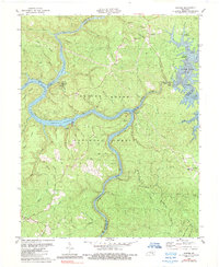
1980 Map of Sawyer
USGS Topo · Published 1989About this map
The Daniel Boone National Forest serves as the backdrop for this study of the confluence of several major waterways, including the Rockcastle River, the Cumberland River, and the Laurel River. The landscape is dominated by the newly formed Laurel River Lake, which had recently altered the local topography with its elevation reaching 1018 feet. In the southern and western portions of the sheet, the Lake Cumberland waters wind through deep valleys, flanked by ridges such as Pote Ridge and Goodin Ridge. Small communities like Baldrock and Sawyer anchor the highlands, where local life centered around Youngs Chapel and Pointers Chapel. This 1980s record captures the transition of the region into a recreation-focused area, marked by the emergence of the Sheltowee Trace trail and numerous campgrounds like Rockcastle Campground.
Find a feature on this map
91 named features on this map. Tap any name to fly to it.
Don’t see what you’re looking for? This feature index may not catch every label — zoom into the map to look around manually.
Map Details
Editions of this 1980 Sawyer Map
2 editions found
Other maps of this area

1890 · Williamsburg
USGS Topo · 1:125,000

1893 · London
USGS Topo · 1:125,000

1894 · Williamsburg
USGS Topo · 1:125,000

1897 · London
USGS Topo · 1:125,000

1952 · Wofford
USGS Topo · 1:24,000

1952 · Hail
USGS Topo · 1:24,000

1952 · London SW
USGS Topo · 1:24,000

1952 · Vox
USGS Topo · 1:24,000

1952 · Ano
USGS Topo · 1:24,000

1952 · Wiborg
USGS Topo · 1:24,000