
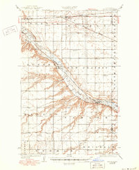
1929 Map of Sawyer
USGS Topo · Published 1929About this map
The Souris River cuts a deep, winding valley across this central Ward County landscape, creating a sharp contrast between the river bottom and the surrounding North Prairie. Two major rail lines dominate the transport geography: the Great Northern runs along the northern edge through Surrey, while the Minneapolis St Paul and Sault Ste Marie follows the river's path, serving the settlements of Logan and Sawyer.
Find a feature on this map
26 named features on this map. Tap any name to fly to it.
Don’t see what you’re looking for? This feature index may not catch every label — zoom into the map to look around manually.
Map Details
Editions of this 1929 Sawyer Map
2 editions found
Other maps of this area

1928 · Minot
USGS Topo · 1:62,500

1929 · Benedict
USGS Topo · 1:62,500

1929 · Kongsberg
USGS Topo · 1:62,500

1948 · Velva
USGS Topo · 1:62,500

1948 · Sawyer
USGS Topo · 1:24,000

1948 · Burlington
USGS Topo · 1:62,500

1948 · Surrey
USGS Topo · 1:24,000

1949 · Norwich
USGS Topo · 1:24,000

1949 · Sawyer
USGS Topo · 1:24,000

1949 · Sawyer NE
USGS Topo · 1:24,000