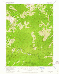
1955 Map of Sawyers Bar
USGS Topo · Published 1961About this map
Sawyers Bar serves as the primary hub of this high-elevation landscape, where the North Fork Salmon River and South Fork Salmon River define the deep drainage patterns of the Klamath National Forest. The 1955 survey captures an era when mining remained a tangible part of the local geography, as evidenced by a high density of claims such as the Wilson Mine, Snoozer Mine, and Star of the West Mine. These operations are clustered around the river forks and deep gulches, often accessed by remote cabin outposts like the Ahlgren Cabin and Tom Taylor Cabin.
Find a feature on this map
105 named features on this map. Tap any name to fly to it.
Don’t see what you’re looking for? This feature index may not catch every label — zoom into the map to look around manually.
Map Details
Editions of this 1955 Sawyers Bar Map
3 editions found

Other maps of this area

1886 · Shasta
USGS Topo · 1:250,000

1894 · Shasta
USGS Topo · 1:250,000

1914 · Seiad
USGS Topo · 1:125,000

1922 · Seiad
USGS Topo · 1:125,000

1923 · Sawyers Bar
USGS Topo · 1:125,000

1931 · Etna
USGS Topo · 1:96,000

1932 · Yreka
USGS Topo · 1:96,000

1934 · Etna
USGS Topo · 1:125,000

1939 · Yreka
USGS Topo · 1:125,000

1948 · Weed
USGS Topo · 1:250,000