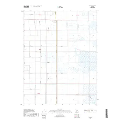
2018 Map of Saxon
USGS Topo · Published 2018About this map
The agricultural grid of the Central Valley dominates this landscape on the border of Solano and Yolo Counties. Small settlements like Saxon and Yolano serve as anchors for the surrounding farm tracts, connected by a network of rural roads such as Yolano Rd and Mills Rd. In the north, the Tremont Cem stands as a significant local landmark, preserving genealogical history for the area's early farming families.
Find a feature on this map
49 named features on this map. Tap any name to fly to it.
Don’t see what you’re looking for? This feature index may not catch every label — zoom into the map to look around manually.
Map Details
Editions of this 2018 Saxon Map
This is the sole edition of this map. No revisions or reprints were ever made.
Other maps of this area

1907 · Woodland
USGS Topo · 1:62,500

1907 · Davisville
USGS Topo · 1:62,500

1908 · Vacaville
USGS Topo · 1:62,500

1908 · Courtland
USGS Topo · 1:62,500

1915 · Swingle
USGS Topo · 1:31,680

1915 · Merritt
USGS Topo · 1:31,680

1916 · Dixon
USGS Topo · 1:31,680

1916 · Cache Slough
USGS Topo · 1:31,680
1916 · Lovdal
USGS Topo · 1:31,680

1916 · Vorden
USGS Topo · 1:31,680