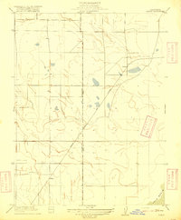
1916 Map of Saxon
USGS Topo · Published 1916About this map
Oakland Antioch and Eastern electric railway tracks cut a sharp diagonal through this 1916 landscape, connecting the rural reaches of Solano and Yolo counties. This corridor represents a brief, high-speed era of interurban travel before the widespread dominance of the automobile. The terrain is marked by the sprawling Yolo Basin in the southeast corner, reflecting the seasonally inundated floodplains of the Sacramento Valley. Small agricultural sidings and stops like Saxon and Millar anchor the railroad line, serving as vital shipping points for local farmers. The map captures a grid-based land system defined by section lines and drainage patterns, illustrating how early 20th-century California managed water and transit across the low-lying valley floor. Genealogists may find interest in the precise placement of these early rail stops and the transition of the Boundary Line between the two counties.
Find a feature on this map
6 named features on this map. Tap any name to fly to it.
Don’t see what you’re looking for? This feature index may not catch every label — zoom into the map to look around manually.
Map Details
Editions of this 1916 Saxon Map
This is the sole edition of this map. No revisions or reprints were ever made.
Other maps of this area

1907 · Woodland
USGS Topo · 1:62,500

1907 · Davisville
USGS Topo · 1:62,500

1908 · Vacaville
USGS Topo · 1:62,500

1908 · Courtland
USGS Topo · 1:62,500

1915 · Swingle
USGS Topo · 1:31,680

1915 · Merritt
USGS Topo · 1:31,680

1916 · Dixon
USGS Topo · 1:31,680

1916 · Cache Slough
USGS Topo · 1:31,680
1916 · Lovdal
USGS Topo · 1:31,680

1916 · Vorden
USGS Topo · 1:31,680