
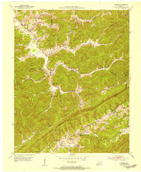
1952 Map of Saxton
USGS Topo · Published 1954About this map
Cumberland River meanders through the northern hills of Whitley County, defining a landscape shaped by narrow hollows and high ridges like Bowling Mountain and Powers Mountain. In the early 1950s, this region was a network of small coal mining communities and agricultural settlements connected by the Louisville and Nashville railroad. Industrial activity is evident at Gatliff and through various Strip Mines, while the social fabric of the era is preserved in the placement of local institutions such as Siler Chapel, Tulip Sch, and the Upper Mulberry Sch. The importance of water and transport is highlighted by the winding course of Patterson Creek and the river bends at Maiden Bend and Horseshoe Bend. Genealogy researchers will find significant value in the mapped locations of remote burial grounds like Powers Cem and the small post office at Yaden (Verne P O).
Find a feature on this map
58 named features on this map. Tap any name to fly to it.
Don’t see what you’re looking for? This feature index may not catch every label — zoom into the map to look around manually.
Map Details
Editions of this 1952 Saxton Map
This is the sole edition of this map. No revisions or reprints were ever made.
Other maps of this area

1886 · Cumberland Gap
USGS Topo · 1:125,000

1888 · Cumberland Gap
USGS Topo · 1:125,000

1890 · Williamsburg
USGS Topo · 1:125,000

1891 · Cumberland Gap
USGS Topo · 1:125,000

1894 · Williamsburg
USGS Topo · 1:125,000

1952 · Wofford
USGS Topo · 1:24,000

1952 · Barbourville
USGS Topo · 1:24,000

1952 · Rockholds
USGS Topo · 1:24,000

1952 · Williamsburg
USGS Topo · 1:24,000
1952 · Frakes
USGS Topo · 1:24,000