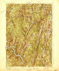
1933 Map of Saxtons River
USGS Topo · Published 1933About this map
State Geologist Geo. H. Perkins oversaw this topographic study during a transitional era for rural Vermont, as the state began incorporating aerial photography into traditional ground surveying. The landscape is defined by the winding course of the Saxtons River and the West River, which carved the valleys where settlements like Grafton and Athens took root. The Rutland RR follows the Williams River in the northeast, connecting Bartonsville and Rockingham to wider markets, while smaller hamlets such as Houghtonville and Cambridgeport remain tied to the river-bottom roads.
Find a feature on this map
82 named features on this map. Tap any name to fly to it.
Don’t see what you’re looking for? This feature index may not catch every label — zoom into the map to look around manually.
Map Details
Editions of this 1933 Saxtons River Map
4 editions found

Other maps of this area

1889 · Wilmington
USGS Topo · 1:62,500

1891 · Wilmington
USGS Topo · 1:62,500

1891 · Brattleboro
USGS Topo · 1:62,500

1893 · Wallingford
USGS Topo · 1:62,500

1893 · Brattleboro
USGS Topo · 1:62,500

1894 · Londonderry
USGS Topo · 1:62,500

1898 · Keene
USGS Topo · 1:62,500

1899 · Londonderry
USGS Topo · 1:62,500

1899 · Wilmington
USGS Topo · 1:62,500

1926 · Claremont
USGS Topo · 1:62,500