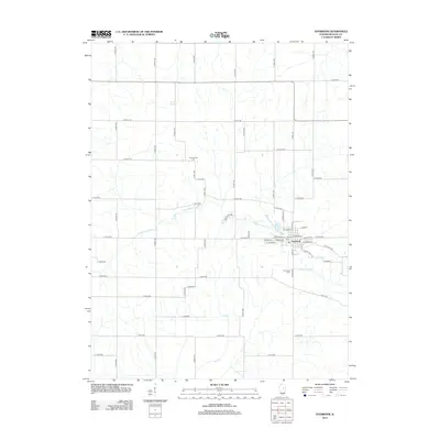
2012 Map of Saybrook
USGS Topo · Published 2012About this map
Saybrook serves as the central hub of this McLean County landscape, where the street grid is anchored by Main St and W Locust St. The settlement is closely tied to the winding path of the Sangamon River, which cuts across the central portion of the map, while Salt Cr flows through the southern reaches. This 2012 survey illustrates the transition from the structured town blocks of Saybrook to a wide-reaching network of agricultural roads, such as N 3400 E Rd and E 1400 N Rd. Several burial grounds, including Riverside Cem and Greenwood Cem, are positioned at the town's periphery, providing specific points of interest for genealogists tracing local families in this part of Illinois. The map captures the enduring rural character of the region, where waterways and a precise grid of county roads define the movement of people and commerce.
Find a feature on this map
55 named features on this map. Tap any name to fly to it.
Don’t see what you’re looking for? This feature index may not catch every label — zoom into the map to look around manually.
Map Details
Editions of this 2012 Saybrook Map
This is the sole edition of this map. No revisions or reprints were ever made.
Other maps of this area

1928 · Gibson City
USGS Topo · 1:62,500

1947 · Sibley
USGS Topo · 1:62,500

1949 · Sibley
USGS Topo · 1:62,500

1952 · Arrowsmith
USGS Topo · 1:62,500

1957 · Gibson City
USGS Topo · 1:62,500

1957 · Colfax
USGS Topo · 1:62,500

1958 · Peoria
USGS Topo · 1:250,000

1961 · Peoria
USGS Topo · 1:250,000

1963 · Peoria
USGS Topo · 1:250,000
1982 · Gibson City West
USGS Topo · 1:24,000