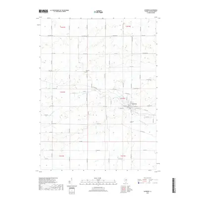
2018 Map of Saybrook
USGS Topo · Published 2018About this map
Saybrook serves as the primary community hub on this Central Illinois prairie landscape, situated where the Sangamon River begins to wind through the townships. The village is well-documented with several distinct burial grounds, including the Old Township Cem and the Township Cem near the town center, as well as Riverside Cem tucked along the riverbanks to the south. Further north, the Greenwood Cem sits alone among the agricultural plots, providing a clear focal point for genealogical research in this part of McLean County.
Find a feature on this map
44 named features on this map. Tap any name to fly to it.
Don’t see what you’re looking for? This feature index may not catch every label — zoom into the map to look around manually.
Map Details
Editions of this 2018 Saybrook Map
This is the sole edition of this map. No revisions or reprints were ever made.
Other maps of this area

1928 · Gibson City
USGS Topo · 1:62,500

1947 · Sibley
USGS Topo · 1:62,500

1949 · Sibley
USGS Topo · 1:62,500

1952 · Arrowsmith
USGS Topo · 1:62,500

1957 · Gibson City
USGS Topo · 1:62,500

1957 · Colfax
USGS Topo · 1:62,500

1958 · Peoria
USGS Topo · 1:250,000

1961 · Peoria
USGS Topo · 1:250,000

1963 · Peoria
USGS Topo · 1:250,000
1982 · Gibson City West
USGS Topo · 1:24,000