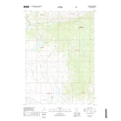
2017 Map of Scab Creek
USGS Topo · Published 2017About this map
Steele Hot Springs and the southern reaches of the Bridger National Forest define this landscape in the Wind River Range foothills. The terrain transitions from the high peaks and glacial features of Boulder Canyon in the north to the sagebrush flats and riparian corridors of the East Fork River in the south. Notable water bodies including Boulder Lake, Soda Lake, and the high-elevation Toboggan Lakes reflect the region's complex hydrology. The presence of named locations such as Moonshine Park and Hall Basin alongside the Scab Creek Rd corridor highlights the intersection of backcountry recreation and historic land use. Topographic landmarks like Lovatt Butte and North Fork Falls serve as distinct navigational points for those exploring this remote section of Sublette County.
Find a feature on this map
31 named features on this map. Tap any name to fly to it.
Don’t see what you’re looking for? This feature index may not catch every label — zoom into the map to look around manually.
Map Details
Editions of this 2017 Scab Creek Map
This is the sole edition of this map. No revisions or reprints were ever made.
Other maps of this area

1938 · Mt Bonneville
USGS Topo · 1:62,500

1941 · Mt Bonneville
USGS Topo · 1:62,500

1942 · Mt Bonneville
USGS Topo · 1:62,500

1955 · Lander
USGS Topo · 1:250,000

1958 · Lander
USGS Topo · 1:250,000

1961 · Lander
USGS Topo · 1:250,000

1964 · Fremont Butte
USGS Topo · 1:24,000

1964 · Boulder Lake
USGS Topo · 1:24,000

1964 · Boulder
USGS Topo · 1:24,000
1968 · Fayette Lake
USGS Topo · 1:24,000