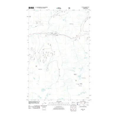
2011 Map of Scenic
USGS Topo · Published 2011About this map
Scenic is situated at a critical juncture of the Tye River and Deception Creek, reflecting its historical position as a transit point through the Cascades. This 2011 survey documents the transition from high-mountain commerce to recreation, where the Old Cascade Hwy winds past the Deception Falls Picnic Area and several forest service sites like Tye Canyon Campground. The landscape is defined by its verticality, rising from the river valley to prominent peaks such as Mount Sawyer and Spark Plug Mountain. For researchers of mountain history and public lands, the map identifies numerous high-altitude water bodies, including Hamada Lake, Ptarmigan Lake, and Surprise Lake, along with the Surprise Mountain Lookout and the Pieper Pass trail network. These features illustrate the area's development as a gateway for forestry, early automotive travel, and wilderness preservation in the Pacific Northwest.
Find a feature on this map
45 named features on this map. Tap any name to fly to it.
Don’t see what you’re looking for? This feature index may not catch every label — zoom into the map to look around manually.
Map Details
Editions of this 2011 Scenic Map
This is the sole edition of this map. No revisions or reprints were ever made.
Other maps of this area

1902 · Skykomish
USGS Topo · 1:125,000

1905 · Skykomish
USGS Topo · 1:125,000

1957 · Wenatchee
USGS Topo · 1:250,000

1965 · Captain Point
USGS Topo · 1:24,000

1965 · Evergreen Mtn
USGS Topo · 1:24,000

1965 · Stevens Pass
USGS Topo · 1:24,000

1965 · Mount Daniel
USGS Topo · 1:24,000

1965 · Skykomish
USGS Topo · 1:24,000
1965 · Big Snow Mtn
USGS Topo · 1:24,000
1965 · Scenic
USGS Topo · 1:24,000