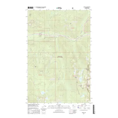
2017 Map of Scenic
USGS Topo · Published 2017About this map
The small mountain settlement of Scenic sits at a critical junction of engineering and nature within the high Cascades. This area is defined by the massive railway projects cutting through the divide, most notably the New Cascade Tunnel and the earlier Cascade Tunnel, which facilitated transport across the steep mountain grades. The surrounding terrain is split between the Snoqualmie National Forest and Wenatchee National Forest, with the King and Chelan County border running along the high peaks. The map reveals a landscape of high alpine basins containing numerous water bodies like Fisher Lake, Surprise Lake, and Lake Clarice. Key transit routes include the historic Old Cascade Hwy and the Pacific Crest National Scenic Trail, which meanders near landmarks such as Pieper Pass and Surprise Mtn. Significant waterfalls, including Deception Falls and Alpine Falls, highlight the dramatic descent of the Tye River through the valley.
Find a feature on this map
52 named features on this map. Tap any name to fly to it.
Don’t see what you’re looking for? This feature index may not catch every label — zoom into the map to look around manually.
Map Details
Editions of this 2017 Scenic Map
This is the sole edition of this map. No revisions or reprints were ever made.
Other maps of this area

1902 · Skykomish
USGS Topo · 1:125,000

1905 · Skykomish
USGS Topo · 1:125,000

1957 · Wenatchee
USGS Topo · 1:250,000

1965 · Captain Point
USGS Topo · 1:24,000

1965 · Evergreen Mtn
USGS Topo · 1:24,000

1965 · Stevens Pass
USGS Topo · 1:24,000

1965 · Mount Daniel
USGS Topo · 1:24,000

1965 · Skykomish
USGS Topo · 1:24,000
1965 · Big Snow Mtn
USGS Topo · 1:24,000
1965 · Scenic
USGS Topo · 1:24,000