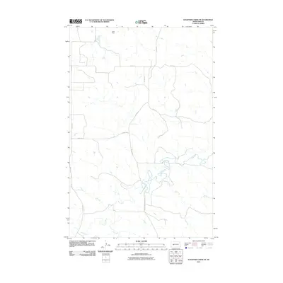
2011 Map of Schaffner Creek NE
USGS Topo · Published 2011About this map
The Knife River meanders across this rural Mercer County landscape, defining the local hydrology alongside tributaries like Gold Creek and Elm Creek. In the northern reaches of the quadrangle, the Wolff Dam stands as a notable water management feature amidst the high plains terrain. The land is organized by a disciplined grid of rural thoroughfares, including north-south corridors like County Rd-5 and 73rd Ave SW, which facilitate movement between the scattered farmsteads and agricultural plots. This survey captures the area in the early 21st century, showing how modern county infrastructure like County Rd-18 and County Rd-7 integrates with the natural drainage patterns of the Missouri River watershed.
Find a feature on this map
11 named features on this map. Tap any name to fly to it.
Don’t see what you’re looking for? This feature index may not catch every label — zoom into the map to look around manually.
Map Details
Editions of this 2011 Schaffner Creek NE Map
This is the sole edition of this map. No revisions or reprints were ever made.
Other maps of this area

1953 · Watford City
USGS Topo · 1:250,000

1954 · McClusky
USGS Topo · 1:250,000

1957 · Watford City
USGS Topo · 1:250,000

1958 · McClusky
USGS Topo · 1:250,000

1967 · Watford City
USGS Topo · 1:250,000

1968 · Medicine Butte
USGS Topo · 1:24,000

1969 · Zap
USGS Topo · 1:24,000
1972 · Medicine Butte SW
USGS Topo · 1:24,000

1973 · Schaffner Creek NE
USGS Topo · 1:24,000

1973 · Willow Creek West
USGS Topo · 1:24,000