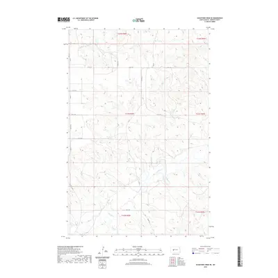
2020 Map of Schaffner Creek NE
USGS Topo · Published 2020About this map
The Knife River meanders across this rural section of Mercer County, joined by the waters of Gold Cr and Elm Cr. The landscape is defined by the Public Land Survey System, with township lines for t143n r90w and t143n r89w dividing the open country. This modern survey reflects a persistent agrarian grid, where section boundaries are traced by a network of local routes such as Co Rd 7, 75th Ave SW, and 14th St SW. The terrain shows the characteristic drainage patterns of the northern plains, where small tributaries feed into the primary river valley. These watercourses and their surrounding plateaus remain the dominant features in an area where human activity is largely mapped by the intersection of section-line roads and the seasonal flow of prairie creeks.
Find a feature on this map
21 named features on this map. Tap any name to fly to it.
Don’t see what you’re looking for? This feature index may not catch every label — zoom into the map to look around manually.
Map Details
Editions of this 2020 Schaffner Creek NE Map
This is the sole edition of this map. No revisions or reprints were ever made.
Other maps of this area

1953 · Watford City
USGS Topo · 1:250,000

1954 · McClusky
USGS Topo · 1:250,000

1957 · Watford City
USGS Topo · 1:250,000

1958 · McClusky
USGS Topo · 1:250,000

1967 · Watford City
USGS Topo · 1:250,000

1968 · Medicine Butte
USGS Topo · 1:24,000

1969 · Zap
USGS Topo · 1:24,000
1972 · Medicine Butte SW
USGS Topo · 1:24,000

1973 · Schaffner Creek NE
USGS Topo · 1:24,000

1973 · Willow Creek West
USGS Topo · 1:24,000