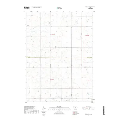
2018 Map of Schaller North
USGS Topo · Published 2018About this map
Schaller serves as the primary community anchor at the southern edge of this West-Central Iowa landscape, where the town grid transitions into a vast network of section roads. The terrain is defined by the gentle drainage of the Little Maple River in the northwest and the Boyer River in the southeast, reflecting the subtle topographic shifts characteristic of the region. This 2018 survey reveals a rural territory deeply rooted in its local history, evidenced by several distinct burial grounds scattered across the townships. These include the Maple Valley Cem, Saint John's Lutheran Cem, and the cluster of Schaller Cem and Saint Joseph Cem located just outside the village limits. The survey also delineates the jurisdictional boundary between Buena Vista County and Sac County, illustrating the geometric precision of the Midwestern township system.
Find a feature on this map
41 named features on this map. Tap any name to fly to it.
Don’t see what you’re looking for? This feature index may not catch every label — zoom into the map to look around manually.
Map Details
Editions of this 2018 Schaller North Map
This is the sole edition of this map. No revisions or reprints were ever made.
Other maps of this area

1954 · Fort Dodge
USGS Topo · 1:250,000

1957 · Fort Dodge
USGS Topo · 1:250,000

1958 · Fort Dodge
USGS Topo · 1:250,000

1967 · Ida Grove NW
USGS Topo · 1:24,000

1969 · Aurelia
USGS Topo · 1:24,000

1969 · Galva
USGS Topo · 1:24,000

1979 · Lakeside
USGS Topo · 1:24,000

1979 · Storm Lake
USGS Topo · 1:24,000

1979 · Alta
USGS Topo · 1:24,000

1979 · Schaller North
USGS Topo · 1:24,000