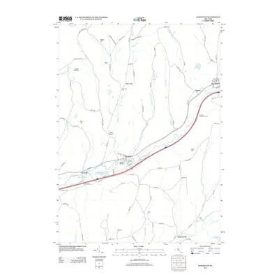
2013 Map of Schenevus
USGS Topo · Published 2013About this map
Schenevus Creek flows through a valley defined by the Interstate 88 corridor, anchoring a series of small settlements including Schenevus, Chaseville, and Tuscan. The landscape is a mix of steep topography, such as Hooker Mountain and Dog Hill, and narrow stream valleys where many family names are preserved on local roads and farmsteads like Willy's Farm. This 2013 survey shows the modern transportation network laid over an older pattern of rural hamlets and small burial grounds, including Schenevus Cem and Bliven Cem. To the north, Elk Creek serves as a secondary focal point for the agricultural uplands. The presence of features like Seward Lake and Clapper Lake suggests a terrain where glacial history has left numerous water bodies and wetlands across the high ground between the Schenevus and Charlotte Creek watersheds.
Find a feature on this map
98 named features on this map. Tap any name to fly to it.
Don’t see what you’re looking for? This feature index may not catch every label — zoom into the map to look around manually.
Map Details
Editions of this 2013 Schenevus Map
This is the sole edition of this map. No revisions or reprints were ever made.
Other maps of this area

1904 · Richmondville
USGS Topo · 1:62,500

1904 · Hobart
USGS Topo · 1:62,500

1907 · Cooperstown
USGS Topo · 1:62,500

1909 · Cooperstown
USGS Topo · 1:62,500

1909 · Delhi
USGS Topo · 1:62,500

1911 · Delhi
USGS Topo · 1:62,500

1943 · Milford
USGS Topo · 1:24,000

1943 · South Valley
USGS Topo · 1:24,000

1943 · Westford
USGS Topo · 1:24,000

1943 · Charlotteville
USGS Topo · 1:24,000