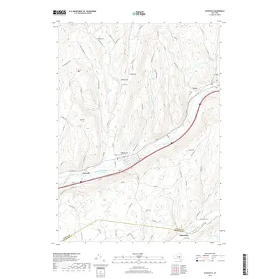
2019 Map of Schenevus
USGS Topo · Published 2019About this map
The Schenevus Creek valley serves as the primary corridor for settlement and transit through this portion of Otsego County. The village of Schenevus stands as the central hub, surrounded by smaller hamlets including Chaseville and Tuscan. The topography is defined by significant elevations such as Hooker Mtn and Badeau Hill, which separate the various drainages feeding into the Charlotte Valley to the south. Numerous family-named landmarks and small burial grounds, such as Bliven Cem and Simpson Cem, are scattered across the landscape, providing essential touchpoints for genealogical research. The presence of Knapp Airport near Elk Creek and the established road network, including the path of Schenevus Cr, illustrates the long-standing importance of this valley in connecting the interior of New York State. The boundary between Otsego and Delaware Counties is clearly delineated as it crosses near Simpsonville, marking a transition in the local jurisdiction.
Find a feature on this map
94 named features on this map. Tap any name to fly to it.
Don’t see what you’re looking for? This feature index may not catch every label — zoom into the map to look around manually.
Map Details
Editions of this 2019 Schenevus Map
This is the sole edition of this map. No revisions or reprints were ever made.
Other maps of this area

1904 · Richmondville
USGS Topo · 1:62,500

1904 · Hobart
USGS Topo · 1:62,500

1907 · Cooperstown
USGS Topo · 1:62,500

1909 · Cooperstown
USGS Topo · 1:62,500

1909 · Delhi
USGS Topo · 1:62,500

1911 · Delhi
USGS Topo · 1:62,500

1943 · Milford
USGS Topo · 1:24,000

1943 · South Valley
USGS Topo · 1:24,000

1943 · Westford
USGS Topo · 1:24,000

1943 · Charlotteville
USGS Topo · 1:24,000