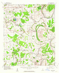
1961 Map of Schlater
USGS Topo · Published 1963About this map
The Tallahatchie River and the Yazoo River dominate this delta landscape in the early 1960s, winding through a complex network of bayous and brakes. The settlement of Schlater and the southern hub of Itta Bena anchor a region defined by its reliance on water and rail. The Columbus and Greenville railroad line cuts across the southern portion of the map, passing by the campus of the Mississippi Vocational College. This era shows a dense social fabric of small rural congregations, including Rock of Ages Ch, Marsh Berea Ch, and Sunnyside Chapel. The terrain is marked by distinctive oxbows and swampy depressions like McNutt Lake and Ashland Brake, illustrating the seasonal flood patterns that have long shaped life in Leflore County.
Find a feature on this map
82 named features on this map. Tap any name to fly to it.
Don’t see what you’re looking for? This feature index may not catch every label — zoom into the map to look around manually.
Map Details
Editions of this 1961 Schlater Map
2 editions found
Other maps of this area

1931 · Schlater
USGS Topo · 1:48,000

1931 · Sumner
USGS Topo · 1:48,000

1931 · Drew
USGS Topo · 1:48,000

1932 · Philipp
USGS Topo · 1:48,000

1934 · Cleveland
USGS Topo · 1:62,500

1934 · Schlater
USGS Topo · 1:62,500

1935 · Sumner
USGS Topo · 1:62,500

1935 · Mound Bayou
USGS Topo · 1:62,500

1935 · Philipp
USGS Topo · 1:62,500

1936 · Greenwood
USGS Topo · 1:62,500