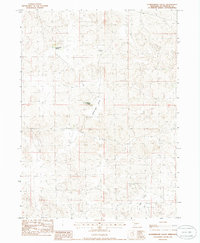
1985 Map of Schneringer Valley
USGS Topo · Published 1986About this map
Schneringer Valley characterizes this high plains landscape in McPherson County, where the topography is defined by the winding depressions of the Sandhills. The area exhibits a sparse settlement pattern typical of western Nebraska ranching country in the early 1980s, anchored by family operations such as the C Pinkerton Ranch in the north and the J Pinkerton Ranch further south. These named ranches serve as vital landmarks in an otherwise vast expanse of undulating terrain, where localized basins like Dishpan Valley and Dane Valley provide the primary geographic structure. Surveyed during the mid-1980s, the map provides a precise look at the township lines of t19n and t18n as they intersect the cattle country of the Nebraska interior.
Find a feature on this map
7 named features on this map. Tap any name to fly to it.
Don’t see what you’re looking for? This feature index may not catch every label — zoom into the map to look around manually.
Map Details
Editions of this 1985 Schneringer Valley Map
This is the sole edition of this map. No revisions or reprints were ever made.
Other maps of this area

1898 · Paxton
USGS Topo · 1:125,000

1899 · North Platte
USGS Topo · 1:125,000

1901 · Paxton
USGS Topo · 1:125,000

1902 · North Platte
USGS Topo · 1:125,000

1949 · Wright Valley
USGS Topo · 1:62,500

1951 · Tryon
USGS Topo · 1:62,500

1951 · Wright Valley
USGS Topo · 1:62,500

1954 · North Platte
USGS Topo · 1:250,000

1956 · North Platte
USGS Topo · 1:250,000

1957 · North Platte
USGS Topo · 1:250,000