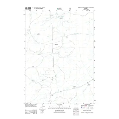
2012 Map of School Section Mountain
USGS Topo · Published 2012About this map
School Section Mountain rises as a central landmark in this high-altitude landscape, where the headwaters of numerous creeks begin their descent through the Laramie Mountains. The map documents a working ranching environment, anchored by established sites such as Sims Ranch, Horr Cow Camp, and Comb Ranch. The drainage patterns are intricate, with W Fork La Bonte Cr and Rocky Ford Cr carving through terrain marked by deep features like Big Bear Canyon and West Fork Canyon. Water management is evident through the presence of the Hildebrand Ditch and Wagonhound Reservoir. High-country navigation is defined by Latham Pass and Chamberlain Pass in the northeast, while the southern reaches are accessed via La Bonte Rd and Fetterman Rd, indicating the historical transit corridors used to move livestock and supplies through this isolated portion of Albany County.
Find a feature on this map
36 named features on this map. Tap any name to fly to it.
Don’t see what you’re looking for? This feature index may not catch every label — zoom into the map to look around manually.
Map Details
Editions of this 2012 School Section Mountain Map
This is the sole edition of this map. No revisions or reprints were ever made.
Other maps of this area

1954 · Torrington
USGS Topo · 1:250,000

1958 · Torrington
USGS Topo · 1:250,000

1964 · Toltec
USGS Topo · 1:24,000

1964 · School Section Mountain
USGS Topo · 1:24,000

1964 · Buffalo Peak
USGS Topo · 1:24,000
1964 · Maneater Creek
USGS Topo · 1:24,000
1964 · Blue Nose Creek
USGS Topo · 1:24,000

1964 · Saddleback Mountain
USGS Topo · 1:24,000

1964 · Windy Peak
USGS Topo · 1:24,000

1964 · Marshall
USGS Topo · 1:24,000