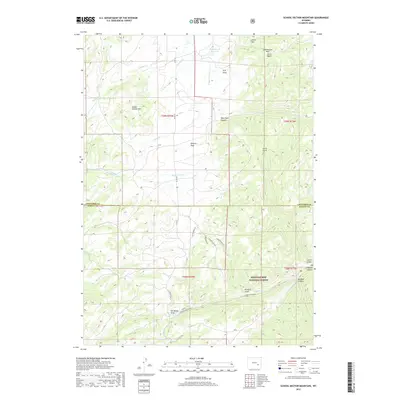
2017 Map of School Section Mountain
USGS Topo · Published 2017About this map
Medicine Bow National Forest dominates the southern half of this landscape, where the high-elevation terrain of the Sierra Madre is incised by deep drainages like Big Bear Canyon and La Bonte Canyon. The boundary between Converse and Albany Counties cuts across the center of the sheet, dividing a region defined by its complex hydrology and dramatic relief. Numerous draws and gulches, including Old Maids Draw and Curtis Gulch, channel water toward the significant La Bonte Cr system. In the north, School Section Mtn rises above Downey Park, while the Wagonhound Reservoir provides a primary water source. The road network is sparse, consisting largely of named forest routes like La Bonte Canyon Rd and local connectors such as W Lodgepine Ln, reflecting the area's use for resource management and wilderness access.
Find a feature on this map
39 named features on this map. Tap any name to fly to it.
Don’t see what you’re looking for? This feature index may not catch every label — zoom into the map to look around manually.
Map Details
Editions of this 2017 School Section Mountain Map
This is the sole edition of this map. No revisions or reprints were ever made.
Other maps of this area

1954 · Torrington
USGS Topo · 1:250,000

1958 · Torrington
USGS Topo · 1:250,000

1964 · Toltec
USGS Topo · 1:24,000

1964 · School Section Mountain
USGS Topo · 1:24,000

1964 · Buffalo Peak
USGS Topo · 1:24,000
1964 · Maneater Creek
USGS Topo · 1:24,000
1964 · Blue Nose Creek
USGS Topo · 1:24,000

1964 · Saddleback Mountain
USGS Topo · 1:24,000

1964 · Windy Peak
USGS Topo · 1:24,000

1964 · Marshall
USGS Topo · 1:24,000