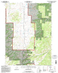
1992 Map of School Section Mtn
USGS Topo · Published 1996About this map
School Section Mountain dominates the northwestern landscape of this Wyoming survey, where the Medicine Bow National Forest meets the high plains of the Converse and Albany County line. The historic transport corridor of the Old Fort Fetterman Road bisects the terrain, tracing a path through a region defined by ranching and resource extraction. Evidence of the area's rural industry is found at the Pyramid Mine and scattered outposts like the Horr Cow Camp, Sims Ranch, and the Arnold Place.
Find a feature on this map
31 named features on this map. Tap any name to fly to it.
Don’t see what you’re looking for? This feature index may not catch every label — zoom into the map to look around manually.
Map Details
Editions of this 1992 School Section Mtn Map
This is the sole edition of this map. No revisions or reprints were ever made.
Other maps of this area

1954 · Torrington
USGS Topo · 1:250,000

1958 · Torrington
USGS Topo · 1:250,000

1964 · Toltec
USGS Topo · 1:24,000

1964 · School Section Mountain
USGS Topo · 1:24,000

1964 · Buffalo Peak
USGS Topo · 1:24,000
1964 · Maneater Creek
USGS Topo · 1:24,000
1964 · Blue Nose Creek
USGS Topo · 1:24,000

1964 · Saddleback Mountain
USGS Topo · 1:24,000

1964 · Windy Peak
USGS Topo · 1:24,000

1964 · Marshall
USGS Topo · 1:24,000