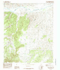
1985 Map of Schott Mountain
USGS Topo · Published 1985About this map
Prairie Dog Town Fork Red River defines the northern reaches of this landscape, carving a wide path through the Briscoe County terrain. The 1980s topography reveals a complex network of draws and canyons, including Indian Creek, Rough Creek, and Folley Canyon, all draining toward the river's corridor. To the south, the prominent ridge of Schott Mountain overlooks Karnes Flat, a geographic transition that likely influenced local movement and grazing patterns. Human presence in this arid environment is marked by numerous water collection points like Wagon Wheel Tank, Bass Tank, and Horseshoe Tank. Small oases such as Minnow Spring and Terry Spring offer rare natural water sources in a landscape otherwise dominated by seasonal drainage features like Long Draw and Little Cleveland Draw. This survey provides a clear look at the ranching infrastructure and natural water features of the Texas Panhandle before the turn of the 21st century.
Find a feature on this map
24 named features on this map. Tap any name to fly to it.
Don’t see what you’re looking for? This feature index may not catch every label — zoom into the map to look around manually.
Map Details
Editions of this 1985 Schott Mountain Map
This is the sole edition of this map. No revisions or reprints were ever made.
Other maps of this area

1954 · Plainview
USGS Topo · 1:250,000

1958 · Plainview
USGS Topo · 1:250,000

1960 · Indian Peak
USGS Topo · 1:62,500

1960 · Brice
USGS Topo · 1:62,500

1967 · Hay Lake
USGS Topo · 1:24,000

1967 · Turkey
USGS Topo · 1:24,000

1967 · Lake Theo
USGS Topo · 1:24,000
1976 · Indian Peak SW
USGS Topo · 1:24,000

1976 · Brice NW
USGS Topo · 1:24,000
1976 · Indian Peak NW
USGS Topo · 1:24,000