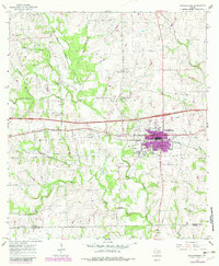
1965 Map of Schulenburg
USGS Topo · Published 1982About this map
Schulenburg sits at the heart of this mid-1960s landscape, positioned along the Southern Pacific railroad line where the urban footprint shows expansion into the surrounding Fayette County fields. The map records a dense network of rural landmarks, including the historic community of High Hill to the north and St John to the south, both hubs for local farm families. Cultural life of the era is evidenced by the Drive-in Theater east of town and the Freyburg Community Hall nestled near the headwaters of Bee Creek. Drainage patterns are defined by the West Navidad River and its numerous tributaries like Mulberry Creek and Rocky Creek, which carve through the terrain. Genealogists will find significant value in the documentation of several burial sites, including Old High Hill Cem, Fitzgerald Cem, and Lyons Cem near Corinth Ch.
Find a feature on this map
32 named features on this map. Tap any name to fly to it.
Don’t see what you’re looking for? This feature index may not catch every label — zoom into the map to look around manually.
Map Details
Editions of this 1965 Schulenburg Map
2 editions found
Other maps of this area

1901 · Flatonia
USGS Topo · 1:125,000

1919 · Schulenburg
USGS Topo · 1:62,500

1953 · Seguin
USGS Topo · 1:250,000

1956 · La Grange
USGS Topo · 1:62,500

1957 · Ammannsville
USGS Topo · 1:24,000

1958 · Seguin
USGS Topo · 1:250,000

1965 · Oakland
USGS Topo · 1:24,000

1965 · Muldoon
USGS Topo · 1:24,000
1965 · Weimar
USGS Topo · 1:24,000

1965 · Schulenburg
USGS Topo · 1:24,000