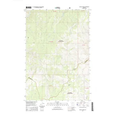
2017 Map of Schultz Saddle
USGS Topo · Published 2017About this map
The Continental Divide serves as the primary geographic and political boundary on this map, separating the Bitterroot National Forest in Ravalli Co from the Beaverhead National Forest in Beaverhead Co. This high-altitude landscape is defined by the peaks of the Anaconda Range, where drainage systems like the East Fork Bitterroot River and Schultz Cr originate. The topography is documented during a period of modern forest management, showing an intricate network of forest roads such as Tie Creek Rd and Schultz Tie Rd that navigate the steep slopes of Tolan Ridge and Hilltop. The map provides a detailed view of the watershed patterns in this section of the Bitterroot Mountains, where numerous small tributaries like Mink Cr, Lodgepole Cr, and Bugle Cr carve through the heavily timbered terrain near Schultz Saddle.
Find a feature on this map
33 named features on this map. Tap any name to fly to it.
Don’t see what you’re looking for? This feature index may not catch every label — zoom into the map to look around manually.
Map Details
Editions of this 2017 Schultz Saddle Map
This is the sole edition of this map. No revisions or reprints were ever made.
Other maps of this area

1955 · Dillon
USGS Topo · 1:250,000

1957 · Dillon
USGS Topo · 1:250,000

1958 · Dillon
USGS Topo · 1:250,000

1962 · Dillon
USGS Topo · 1:250,000

1965 · Dillon
USGS Topo · 1:250,000

1966 · Lost Trail Pass
USGS Topo · 1:24,000

1966 · Big Hole Battlefield
USGS Topo · 1:24,000
1966 · Elk Creek
USGS Topo · 1:24,000
1974 · Bender Point
USGS Topo · 1:24,000
1974 · Lick Creek
USGS Topo · 1:24,000