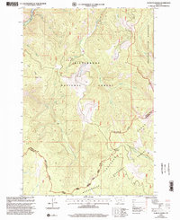
1998 Map of Schultz Saddle
USGS Topo · Published 2002About this map
The Anaconda Range and the Continental Divide define the high-altitude landscape of this 1990s survey, marking the boundary between Ravalli and Beaverhead counties. The terrain is characterized by a dense network of watercourses, including the East Fork Bitterroot River and numerous feeder streams like Meadow Creek and Tolan Creek. Cultural markers are sparse in this protected area, though a Quarry near Springer Creek indicates localized resource extraction near the northern edge of the sheet.
Find a feature on this map
31 named features on this map. Tap any name to fly to it.
Don’t see what you’re looking for? This feature index may not catch every label — zoom into the map to look around manually.
Map Details
Editions of this 1998 Schultz Saddle Map
This is the sole edition of this map. No revisions or reprints were ever made.
Other maps of this area

1955 · Dillon
USGS Topo · 1:250,000

1957 · Dillon
USGS Topo · 1:250,000

1958 · Dillon
USGS Topo · 1:250,000

1962 · Dillon
USGS Topo · 1:250,000

1965 · Dillon
USGS Topo · 1:250,000

1966 · Lost Trail Pass
USGS Topo · 1:24,000

1966 · Big Hole Battlefield
USGS Topo · 1:24,000
1966 · Elk Creek
USGS Topo · 1:24,000
1974 · Bender Point
USGS Topo · 1:24,000
1974 · Lick Creek
USGS Topo · 1:24,000