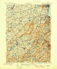
1935 Map of Schunemunk
USGS Topo · Published 1946About this map
The Hudson River shoreline and the interior highlands of Orange County define this landscape as it stood in the mid-1930s. The topographic detail highlights a complex network of rail and road infrastructure, including the Erie RR and the New York Ontario and Western RR, which connected agricultural centers like Washingtonville and Monroe to the river at Cornwall Landing. Industrial and military history is prominent, with the West Point Military Reservation occupying the eastern hills and the Bull Mine located near Oxford Depot.
Find a feature on this map
174 named features on this map. Tap any name to fly to it.
Don’t see what you’re looking for? This feature index may not catch every label — zoom into the map to look around manually.
Map Details
Editions of this 1935 Schunemunk Map
4 editions found

Other maps of this area

1891 · Greenwood Lake
USGS Topo · 1:62,500

1891 · Ramapo
USGS Topo · 1:62,500

1892 · West Point
USGS Topo · 1:62,500

1892 · Tarrytown
USGS Topo · 1:62,500

1893 · Greenwood Lake
USGS Topo · 1:62,500

1893 · Tarrytown
USGS Topo · 1:62,500

1893 · Ramapo
USGS Topo · 1:62,500

1893 · Poughkeepsie
USGS Topo · 1:62,500

1894 · West Point
USGS Topo · 1:62,500

1894 · Poughkeepsie
USGS Topo · 1:62,500