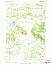
1969 Map of Scio
USGS Topo · Published 1971About this map
Scio sits at the heart of this agricultural landscape in Linn County, where the valley floor meets the rising timber of the Cascade foothills. The town is defined by its relationship with Thomas Creek, which winds through the center of the sheet alongside the Southern Pacific Railroad. This late-1960s survey illustrates a region where transportation infrastructure and traditional farming landmarks remain prominent. The transition from the flat agricultural lands of the Willamette Valley to the more varied terrain of Rogers Mountain and Hungry Hill is punctuated by local history, visible in the distribution of family-named landmarks like Franklin Butte and its associated Franklin Butte Cem. Evidence of the area's rural social structure is found at the Grange Hall and Providence Cem, while several crossings, including the Schimanek Bridge and a notable Covered Bridge over Crabtree Creek, highlight the era's local engineering.
Find a feature on this map
28 named features on this map. Tap any name to fly to it.
Don’t see what you’re looking for? This feature index may not catch every label — zoom into the map to look around manually.
Map Details
Editions of this 1969 Scio Map
2 editions found
Other maps of this area

1911 · Lebanon
USGS Topo · 1:31,680

1921 · Lebanon
USGS Topo · 1:62,500

1922 · Lebanon
USGS Topo · 1:48,000

1924 · Lebanon
USGS Topo · 1:62,500

1925 · Stayton
USGS Topo · 1:62,500

1940 · Lebanon
USGS Topo · 1:62,500

1941 · Stayton
USGS Topo · 1:62,500

1944 · Lebanon
USGS Topo · 1:62,500

1951 · Lyons
USGS Topo · 1:62,500

1951 · Snow Peak
USGS Topo · 1:62,500