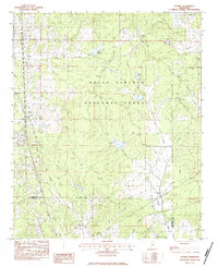
1983 Map of Scobey
USGS Topo · Published 1984About this map
The Holly Springs National Forest dominates the upper half of this terrain on the border of Yalobusha and Grenada Counties. Small settlements like Scobey and Simmons are documented just as they appeared in the early 1980s, along with the rural congregation at Jehovah Ch. The landscape is defined by a dense network of watercourses, including the curiously named Okochickimo Creek and Riverdale Creek, which feed into larger bodies like Lake Tillatoba.
Find a feature on this map
25 named features on this map. Tap any name to fly to it.
Don’t see what you’re looking for? This feature index may not catch every label — zoom into the map to look around manually.
Map Details
Editions of this 1983 Scobey Map
This is the sole edition of this map. No revisions or reprints were ever made.
Other maps of this area

1953 · West Point
USGS Topo · 1:250,000

1954 · Grenada
USGS Topo · 1:62,500

1954 · Oakland
USGS Topo · 1:62,500

1954 · Water Valley
USGS Topo · 1:62,500

1955 · Water Valley
USGS Topo · 1:62,500

1955 · Coffeeville
USGS Topo · 1:62,500

1956 · Tupelo
USGS Topo · 1:250,000

1958 · Tupelo
USGS Topo · 1:250,000

1958 · West Point
USGS Topo · 1:250,000

1963 · West Point
USGS Topo · 1:250,000