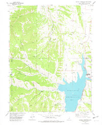
1978 Map of Scofield Reservoir
USGS Topo · Published 1979About this map
Scofield Reservoir dominates the eastern basin of this high-elevation plateau, serving as a critical water resource at the intersection of Utah, Carbon, and Sanpete counties. The landscape is defined by the steep transition from Dry Valley up to the ridges of the Manti-La Sal National Forest. Evidence of the region’s industrial and transit history is visible in the Old Railroad Grade that winds through Starvation Canyon near the distinctive hairpin turn known as The Backswitch. This infrastructure once supported the movement of goods and people across the Bear Ridge backcountry. Recreational development in the late 1970s is captured at the Scofield Lake State Recreation Area and Fish Creek Campground. Smaller localities and family-named landmarks like Bennion, Kelly, and Eternal Flat are documented alongside specialized sites like the Bear Prospect and the Gaging Sta along Fish Creek.
Find a feature on this map
50 named features on this map. Tap any name to fly to it.
Don’t see what you’re looking for? This feature index may not catch every label — zoom into the map to look around manually.
Map Details
Editions of this 1978 Scofield Reservoir Map
This is the sole edition of this map. No revisions or reprints were ever made.
Other maps of this area

1885 · Manti
USGS Topo · 1:250,000

1895 · Manti
USGS Topo · 1:250,000

1923 · Scofield
USGS Topo · 1:62,500

1925 · Scofield
USGS Topo · 1:62,500

1939 · Soldier Summit
USGS Topo · 1:62,500

1942 · Soldier Summit
USGS Topo · 1:62,500

1956 · Price
USGS Topo · 1:250,000

1960 · Price
USGS Topo · 1:250,000

1962 · Price
USGS Topo · 1:250,000

1965 · Fairview Lakes
USGS Topo · 1:24,000