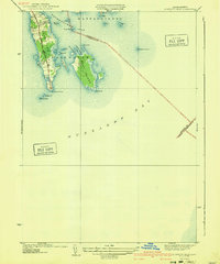
1940 Map of Sconticut Neck
USGS Topo · Published 1940About this map
Sconticut Neck reaches into the waters of Buzzards Bay in this coastal study, detailing a landscape defined by its peninsular geography and outlying islands. Compiled in part from aerial photographs, the map illustrates the primary corridor of Sconticut Neck Road as it leads toward Sconticut Point, providing a window into the pre-war development of this Fairhaven shoreline. To the east, the large mass of West Island is separated from the neck by North Cove and Round Cove, while smaller landmarks like Long Island, Fish I, and Round I dot the inner waters.
Find a feature on this map
26 named features on this map. Tap any name to fly to it.
Don’t see what you’re looking for? This feature index may not catch every label — zoom into the map to look around manually.
Map Details
Editions of this 1940 Sconticut Neck Map
3 editions found
Other maps of this area

1885 · New Bedford
USGS Topo · 1:62,500

1886 · Falmouth
USGS Topo · 1:62,500

1887 · Gay Head
USGS Topo · 1:62,500

1888 · New Bedford
USGS Topo · 1:62,500

1888 · Falmouth
USGS Topo · 1:62,500

1889 · Gay Head
USGS Topo · 1:62,500

1893 · Gay Head
USGS Topo · 1:62,500

1893 · Falmouth
USGS Topo · 1:62,500

1893 · New Bedford
USGS Topo · 1:62,500

1915 · Falmouth
USGS Topo · 1:62,500