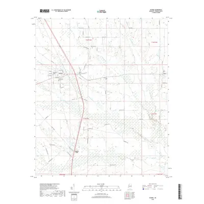
2018 Map of Scooba
USGS Topo · Published 2018About this map
Scooba serves as the focal point of this East Mississippi landscape, situated at a crossroads of commerce and education defined by the campus of East Mississippi Community College and the north-south transit corridor of Old 45. To the south, the settlement of Electric Mills marks a point of historical industry near the marshy banks of Bodka Cr, while the eastern portion of the map transitions toward the rural hamlet of Giles. The terrain is intricately dissected by a network of waterways including Big Scooba Cr, Flat Scooba Cr, and Shu Hammock Cr, which carve through the wooded lowlands. Local history is anchored by several sites of remembrance, notably Cedar Lawn Memorial Cem and the Old Scooba Cem, along with the Blue Chapel located just north of the college grounds.
Find a feature on this map
74 named features on this map. Tap any name to fly to it.
Don’t see what you’re looking for? This feature index may not catch every label — zoom into the map to look around manually.
Map Details
Editions of this 2018 Scooba Map
This is the sole edition of this map. No revisions or reprints were ever made.
Other maps of this area

1953 · Meridian
USGS Topo · 1:250,000

1957 · Meridian
USGS Topo · 1:250,000

1962 · Oak Grove
USGS Topo · 1:24,000

1962 · Shuqualak
USGS Topo · 1:24,000

1963 · Townsend
USGS Topo · 1:24,000

1965 · Meridian
USGS Topo · 1:250,000

1973 · Panola
USGS Topo · 1:24,000

1973 · Scooba
USGS Topo · 1:24,000
1973 · Geiger
USGS Topo · 1:24,000
1973 · Paulette
USGS Topo · 1:24,000