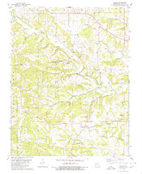
1980 Map of Scopus
USGS Topo · Published 1980About this map
Whitewater River and Little Whitewater Creek dominate this Bollinger County landscape, where the rural settlements of Scopus and Mayfield serve as local hubs. The terrain is deeply carved by drainage systems like James Creek and Panther Creek, creating numerous named hollows such as Camp Hollow and Bull Lot Hollow. This 1980 survey reveals a community anchored by its small country congregations and burial grounds, reflecting generations of local family history. Genealogists will find a wealth of specific data, from the Judge Long Cem and Seabaugh Cem to the Little Whitewater Ch. Notable topographic landmarks like Buck Knob rise above the winding creek beds, while the presence of Stillhouse Spring and Big Blue Spring Branch points to the importance of natural water sources for the area's homesteads and agricultural life.
Find a feature on this map
41 named features on this map. Tap any name to fly to it.
Don’t see what you’re looking for? This feature index may not catch every label — zoom into the map to look around manually.
Map Details
Editions of this 1980 Scopus Map
2 editions found
Other maps of this area

1910 · Higdon
USGS Topo · 1:62,500

1923 · Perryville
USGS Topo · 1:62,500

1924 · Perryville
USGS Topo · 1:62,500

1933 · Marble Hill
USGS Topo · 1:62,500

1933 · Marquand
USGS Topo · 1:62,500

1937 · Marble Hill
USGS Topo · 1:62,500

1938 · Marquand
USGS Topo · 1:62,500

1949 · Paducah
USGS Topo · 1:250,000

1949 · Rolla
USGS Topo · 1:250,000

1950 · Paducah
USGS Topo · 1:250,000