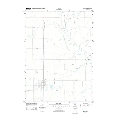
2012 Map of Scotland
USGS Topo · Published 2012About this map
Maxwell Colony sits along the winding course of the James River in this detailed 2012 study of Bon Homme County. The landscape is defined by the intersection of agricultural grid roads and the complex hydrology of Dawson Cr and Lonetree Cr. Near the southern portion of the quadrangle, the settlement area includes the Rose Hill Cemetery and the local Burke Field Airport, while recreation and water management are represented by the presence of Lake Henry. The street plan for Scotland is clearly visible, showing a core centered around Main St and Railway St, reflecting the historic importance of the rail corridor to the town's development. This survey provides a precise account of the rural infrastructure and natural drainage patterns of the Missouri Plateau region just before the mid-2010s.
Find a feature on this map
38 named features on this map. Tap any name to fly to it.
Don’t see what you’re looking for? This feature index may not catch every label — zoom into the map to look around manually.
Map Details
Editions of this 2012 Scotland Map
This is the sole edition of this map. No revisions or reprints were ever made.
Other maps of this area

1898 · Olivet
USGS Topo · 1:125,000

1955 · Sioux Falls
USGS Topo · 1:250,000

1957 · Tschetter Colony
USGS Topo · 1:24,000

1957 · Menno
USGS Topo · 1:24,000

1957 · Wolf Creek
USGS Topo · 1:24,000

1957 · Scotland
USGS Topo · 1:24,000

1958 · Sioux Falls
USGS Topo · 1:250,000

1978 · Tripp SE
USGS Topo · 1:24,000
1978 · Kloucek Lake
USGS Topo · 1:24,000
1978 · Lesterville
USGS Topo · 1:24,000