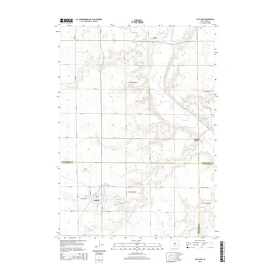
2015 Map of Scotland
USGS Topo · Published 2015About this map
Scotland serves as the primary hub of this landscape, situated at the intersection of a grid of rural roads and adjacent to Dawson Cr. The town's layout is clearly defined, including neighborhood streets like Washington St and Stafford St. To the north of the town center, Rose Hill Cem and the open space of Burke Field provide a transition into the surrounding agricultural terrain. The James River meanders prominently through the northeastern portion of the map, flowing past the Maxwell Colony and near the village of Olivet. Water features are central to the geography here, with Lake Henry and its associated Lake Acc located just east of the main settlement. The intricate drainage network is further defined by Lonetree Cr and S Br Lonetree Cr to the north, and Prairie Cr in the southeast, marking the fertile lowlands of the Bon Homme Co Yankton Co border.
Find a feature on this map
43 named features on this map. Tap any name to fly to it.
Don’t see what you’re looking for? This feature index may not catch every label — zoom into the map to look around manually.
Map Details
Editions of this 2015 Scotland Map
This is the sole edition of this map. No revisions or reprints were ever made.
Other maps of this area

1898 · Olivet
USGS Topo · 1:125,000

1955 · Sioux Falls
USGS Topo · 1:250,000

1957 · Tschetter Colony
USGS Topo · 1:24,000

1957 · Menno
USGS Topo · 1:24,000

1957 · Wolf Creek
USGS Topo · 1:24,000

1957 · Scotland
USGS Topo · 1:24,000

1958 · Sioux Falls
USGS Topo · 1:250,000

1978 · Tripp SE
USGS Topo · 1:24,000
1978 · Kloucek Lake
USGS Topo · 1:24,000
1978 · Lesterville
USGS Topo · 1:24,000