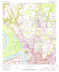
1963 Map of Scotlandville
USGS Topo · Published 1981About this map
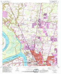
Scotlandville and the expansive Southern University campus anchor this industrial and educational corridor along the eastern bank of the Mississippi River. The map documents a significant mid-century transition, showing the intersection of heavy industry, rail transport, and suburban expansion north of Baton Rouge. Historic landforms like Free Negro Point and Solitude Point remain prominent along the river's winding course, while the interior is marked by institutional landmarks such as Leland College and the State Industrial School for Boys. The logistics of the era are visible in the proximity of Ryan Airport to the Illinois Central Gulf Railroad and the Kansas City Southern Railroad. Scattered throughout the landscape are numerous country churches and cemeteries, including Mt Vernon Ch No 1, Barnes Cem, and the Benevolent Society Cem, which provide essential points of reference for local family history.
Find a feature on this map
65 named features on this map. Tap any name to fly to it.
Don’t see what you’re looking for? This feature index may not catch every label — zoom into the map to look around manually.
Map Details
Editions of this 1963 Scotlandville Map
5 editions found
Other maps of this area

1906 · Bayou Sara
USGS Topo · 1:125,000

1908 · Baton Rouge
USGS Topo · 1:62,500

1939 · Zachary
USGS Topo · 1:62,500

1939 · Baton Rouge
USGS Topo · 1:62,500

1940 · Grosse Tete
USGS Topo · 1:62,500

1953 · Baton Rouge West
USGS Topo · 1:24,000

1953 · Lobdell
USGS Topo · 1:24,000
1953 · Baton Rouge East
USGS Topo · 1:24,000

1953 · Comite
USGS Topo · 1:24,000

1954 · Zachary
USGS Topo · 1:24,000