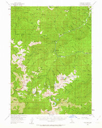
1955 Map of Scott Bar
USGS Topo · Published 1963About this map
The Scott River winds through the steep Siskiyou terrain, anchoring a landscape defined by mid-century resource management and wilderness recreation. This 1950s survey documents the infrastructure of the Klamath National Forest, highlighting the network of remote outposts such as the Scott Bar Guard Sta and the Kelsey Creek Guard Station. The map captures the era of the high-country camp culture, with numerous named sites like Rancheria Camp, Stud Horse Camp, and Whisky Camp providing base points for forest travel. Geological interests are evidenced by the McGarvy Prospect and the Anthony Mine Camp near the southern boundary. Significant natural landmarks, including the high peaks of the Marble Mountains and distinctive formations like Kings Castle, are shown alongside the intricate drainage systems of Grider Creek and Middle Creek.
Find a feature on this map
148 named features on this map. Tap any name to fly to it.
Don’t see what you’re looking for? This feature index may not catch every label — zoom into the map to look around manually.
Map Details
Editions of this 1955 Scott Bar Map
3 editions found

Other maps of this area

1886 · Shasta
USGS Topo · 1:250,000

1894 · Shasta
USGS Topo · 1:250,000

1914 · Seiad
USGS Topo · 1:125,000

1922 · Seiad
USGS Topo · 1:125,000

1923 · Sawyers Bar
USGS Topo · 1:125,000

1931 · Etna
USGS Topo · 1:96,000

1932 · Yreka
USGS Topo · 1:96,000

1934 · Etna
USGS Topo · 1:125,000

1939 · Yreka
USGS Topo · 1:125,000

1948 · Weed
USGS Topo · 1:250,000