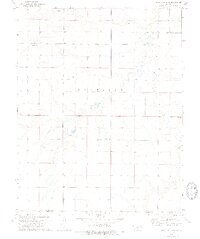
1974 Map of Scott City 4 SE
USGS Topo · Published 1976About this map
Pawnee River meanders across this high plains landscape on the border of Finney and Gray counties during the mid-1970s. The terrain is characterized by broad upland flats and gradual drainage basins, where water sources like a Spring and various Wells were essential to local ranching and agricultural operations. The map captures a specific moment in the rural development of the region, noting the location of Theoni Sch on the eastern edge of the quadrangle.
Find a feature on this map
10 named features on this map. Tap any name to fly to it.
Don’t see what you’re looking for? This feature index may not catch every label — zoom into the map to look around manually.
Map Details
Editions of this 1974 Scott City 4 SE Map
2 editions found
Other maps of this area

1892 · Dodge
USGS Topo · 1:125,000

1896 · Garden
USGS Topo · 1:125,000

1955 · Dodge City
USGS Topo · 1:250,000

1955 · Scott City
USGS Topo · 1:250,000

1958 · Dodge City
USGS Topo · 1:250,000

1958 · Scott City
USGS Topo · 1:250,000

1959 · Dodge City
USGS Topo · 1:250,000

1967 · Pierceville
USGS Topo · 1:24,000

1968 · Cimarron NW
USGS Topo · 1:24,000
1968 · Pierceville NE
USGS Topo · 1:24,000