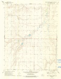
1974 Map of South of Eminence Cemetery
USGS Topo · Published 1993About this map
The Pawnee River meanders across this High Plains landscape, cutting through the townships of Garfield and Logan. This mid-1970s survey illustrates a region defined by its reliance on groundwater and surface resources, marked by numerous Well sites and Wells dispersed across the prairie. The presence of the Theoni Sch suggests a focal point for the rural community, serving families in the northern portion of the county near the Finney and Gray line.
Find a feature on this map
10 named features on this map. Tap any name to fly to it.
Don’t see what you’re looking for? This feature index may not catch every label — zoom into the map to look around manually.
Map Details
Editions of this 1974 South of Eminence Cemetery Map
2 editions found
Other maps of this area

1892 · Dodge
USGS Topo · 1:125,000

1896 · Garden
USGS Topo · 1:125,000

1955 · Dodge City
USGS Topo · 1:250,000

1955 · Scott City
USGS Topo · 1:250,000

1958 · Dodge City
USGS Topo · 1:250,000

1958 · Scott City
USGS Topo · 1:250,000

1959 · Dodge City
USGS Topo · 1:250,000

1967 · Pierceville
USGS Topo · 1:24,000

1968 · Cimarron NW
USGS Topo · 1:24,000
1968 · Pierceville NE
USGS Topo · 1:24,000