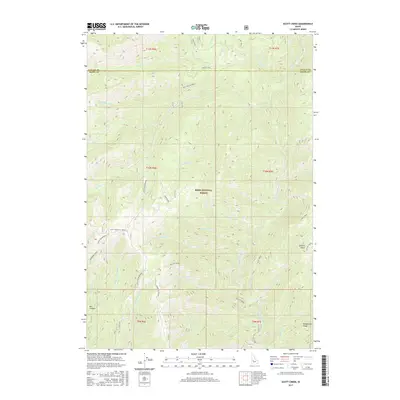
2017 Map of Scott Creek
USGS Topo · Published 2017About this map
Boise National Forest encompasses this wilderness area where the Deadwood River carves through the landscape of the Idaho backcountry. The terrain is defined by prominent high points and tactical observation sites, most notably the Scott Mountain Lookout and the Deadwood Lookout. These points of interest are connected by a network of forest roads and spurs, including the Six Mile Spur and the Camptender road. The hydrography of the region is dense, with Julie Creek and Ninemile Cr feeding into the larger drainage systems. The survey also captures natural features like the steep walls of Box Canyon and the high elevation of Deadwood Ridge, reflecting the topography of the Valley and Boise County border during the early 21st century.
Find a feature on this map
42 named features on this map. Tap any name to fly to it.
Don’t see what you’re looking for? This feature index may not catch every label — zoom into the map to look around manually.
Map Details
Editions of this 2017 Scott Creek Map
This is the sole edition of this map. No revisions or reprints were ever made.
Other maps of this area

1909 · Garden Valley
USGS Topo · 1:125,000

1953 · Boiling Springs
USGS Topo · 1:62,500

1953 · Deadwood Reservoir
USGS Topo · 1:62,500

1957 · Challis
USGS Topo · 1:250,000

1959 · Garden Valley
USGS Topo · 1:62,500

1960 · Challis
USGS Topo · 1:250,000

1963 · Challis
USGS Topo · 1:250,000

1972 · Scott Creek
USGS Topo · 1:24,000
1972 · Miller Mtn West
USGS Topo · 1:24,000
1972 · Lowman
USGS Topo · 1:24,000