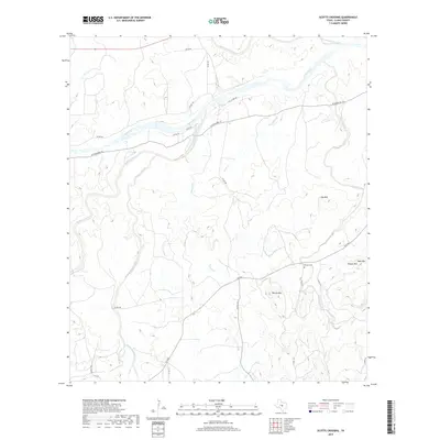
2019 Map of Scotts Crossing
USGS Topo · Published 2019About this map
The Llano River winds through this central Texas landscape, joined by a network of tributaries including San Fernando Creek and Hickory Creek. The terrain is defined by several prominent rises, most notably Hog Mtn, Blount Mtn, and Bear Mtn, which overlook the complex drainage basins of Bullhead Creek and Cottonwood Creek. This 2019 survey documents a rural environment where land use is reflected in the sparse road network, primarily composed of county roads like Co RD 102 and W Ranch Rd 152. Genealogists and local historians will find the Sixmile Cem situated near the intersection of FM 2323 and Sixmile Creek, a key landmark for tracing family roots in this portion of Llano County. The map provides a clear record of the area's physical geography, from the banks of Owen Creek to the summit of Hobson Mtn.
Find a feature on this map
29 named features on this map. Tap any name to fly to it.
Don’t see what you’re looking for? This feature index may not catch every label — zoom into the map to look around manually.
Map Details
Editions of this 2019 Scotts Crossing Map
This is the sole edition of this map. No revisions or reprints were ever made.
Other maps of this area

1887 · Llano
USGS Topo · 1:125,000

1894 · Llano
USGS Topo · 1:125,000

1904 · Llano
USGS Topo · 1:125,000

1909 · Llano
USGS Topo · 1:125,000

1918 · Llano
USGS Topo · 1:125,000

1954 · Llano
USGS Topo · 1:250,000

1955 · Llano
USGS Topo · 1:250,000

1955 · Valley Spring
USGS Topo · 1:24,000
1955 · Llano North
USGS Topo · 1:24,000
1955 · Smoothingiron Mountain
USGS Topo · 1:24,000