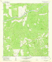
1960 Map of Scotts Crossing
USGS Topo · Published 1962About this map
The Llano River winds through the heart of this Llano County landscape, its course defined by rugged Texas Hill Country terrain and numerous seasonal drainages. During the early 1960s, this area remained largely rural, centered on the small settlement of Scotts Crossing. The topography is punctuated by several prominent peaks, including Hog Mountain and Blount Mountain, while a localized Quarry in the southeast suggests the importance of granite or stone extraction to the local economy.
Find a feature on this map
15 named features on this map. Tap any name to fly to it.
Don’t see what you’re looking for? This feature index may not catch every label — zoom into the map to look around manually.
Map Details
Editions of this 1960 Scotts Crossing Map
This is the sole edition of this map. No revisions or reprints were ever made.
Other maps of this area

1887 · Llano
USGS Topo · 1:125,000

1894 · Llano
USGS Topo · 1:125,000

1904 · Llano
USGS Topo · 1:125,000

1909 · Llano
USGS Topo · 1:125,000

1918 · Llano
USGS Topo · 1:125,000

1954 · Llano
USGS Topo · 1:250,000

1955 · Llano
USGS Topo · 1:250,000

1955 · Valley Spring
USGS Topo · 1:24,000
1955 · Llano North
USGS Topo · 1:24,000
1955 · Smoothingiron Mountain
USGS Topo · 1:24,000