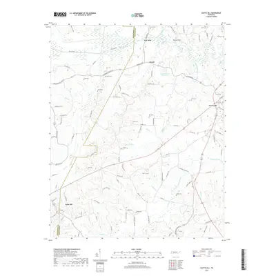
2019 Map of Scotts Hill
USGS Topo · Published 2019About this map
Decaturville sits at the eastern edge of this landscape, its street grid organized around W Main St and S West St, while the community of Scotts Hill anchors the southwestern corner. The terrain is defined by the Beech River and its intricate drainage network, including the channelized New Canal Rd. This 2019 survey documents a rural landscape heavily marked by family history and genealogy, with numerous small burial grounds such as Yarbro Cem, Hensley Cem, and Rosson Cem scattered across the uplands. Small settlements like Dixie Mills and Garrett persist as quiet crossroads, while water features like Festus Jackson Lake and Lewis Lacy Lake Number Two indicate the management of local tributaries like Turkey Creek. The boundary between Henderson Co and Decatur Co cuts diagonally through the center, bisecting a region of ridges and hollows like Buckner Hollow.
Find a feature on this map
114 named features on this map. Tap any name to fly to it.
Don’t see what you’re looking for? This feature index may not catch every label — zoom into the map to look around manually.
Map Details
Editions of this 2019 Scotts Hill Map
This is the sole edition of this map. No revisions or reprints were ever made.
Other maps of this area

1936 · Scotts Hill
USGS Topo · 1:24,000

1936 · Parsons
USGS Topo · 1:24,000

1936 · Thurman
USGS Topo · 1:24,000

1936 · Bath Springs
USGS Topo · 1:24,000

1936 · Sardis
USGS Topo · 1:24,000

1936 · Jeannette
USGS Topo · 1:24,000

1936 · Reagan
USGS Topo · 1:24,000

1936 · Perryville
USGS Topo · 1:24,000

1936 · Chesterfield
USGS Topo · 1:24,000

1949 · Perryville
USGS Topo · 1:24,000