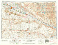
1954 Map of Scottsbluff
USGS Topo · Published 1965About this map
Scotts Bluff National Monument and the surrounding high plains are documented here during a period of mid-century infrastructure growth. The North Platte River serves as the central artery for the region, paralleled by the Union Pacific railroad and a network of irrigation works like the Tri-State Canal. This landscape is defined by its iconic geological markers, including the legendary Chimney Rock, Castle Rock, and Courthouse Rock, which served as vital landmarks for westward travelers.
Find a feature on this map
53 named features on this map. Tap any name to fly to it.
Don’t see what you’re looking for? This feature index may not catch every label — zoom into the map to look around manually.
Map Details
Editions of this 1954 Scottsbluff Map
3 editions found

Other maps of this area

1896 · Patrick
USGS Topo · 1:125,000

1896 · Browns Creek
USGS Topo · 1:125,000

1897 · Ogallala
USGS Topo · 1:125,000

1898 · Scotts Bluff
USGS Topo · 1:125,000

1898 · Camp Clarke
USGS Topo · 1:125,000

1899 · Browns Creek
USGS Topo · 1:125,000

1899 · Sidney
USGS Topo · 1:125,000

1899 · Goshen Hole
USGS Topo · 1:125,000

1899 · Whistle Creek
USGS Topo · 1:125,000

1900 · Chappell
USGS Topo · 1:125,000