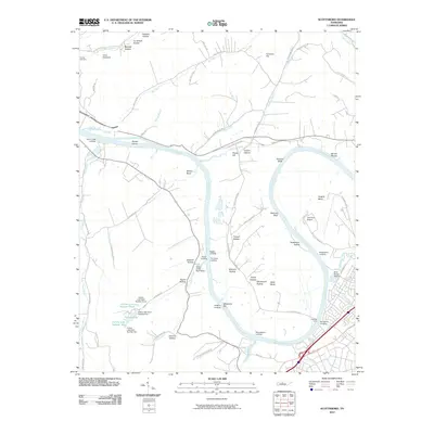
2010 Map of Scottsboro
USGS Topo · Published 2010About this map
The Cumberland River carves a deep, winding path through this portion of Davidson County, creating prominent topographical features like Bells Bend, Whites Bend, and Cockrill Bend. This 2010 survey illustrates the area's mix of riverside industry, aviation, and rural hollows. Significant river access points such as Cleeces Ferry, Indian Creek Boat Ramp, and Rock Harbor Marina indicate the waterway's continued importance for transport and recreation. To the east, the John Tune Airport occupies a large loop in the river, while the western landscape is dominated by narrow valleys like Tidwell Hollow and Dozier Hollow. Genealogists and local historians can find family-named landmarks including Gower Island and Carney Cemetery, alongside several historical landings such as Timmons Landing and Bloomsteins Landing.
Find a feature on this map
81 named features on this map. Tap any name to fly to it.
Don’t see what you’re looking for? This feature index may not catch every label — zoom into the map to look around manually.
Map Details
Editions of this 2010 Scottsboro Map
This is the sole edition of this map. No revisions or reprints were ever made.
Other maps of this area

1903 · Nashville
USGS Topo · 1:125,000

1930 · White Bluff
USGS Topo · 1:62,500

1931 · Ridgetop
USGS Topo · 1:62,500

1932 · Nashville
USGS Topo · 1:62,500

1933 · White Bluff
USGS Topo · 1:62,500

1935 · Ridgetop
USGS Topo · 1:62,500

1952 · Nashville West
USGS Topo · 1:24,000
1953 · Oak Hill
USGS Topo · 1:24,000

1955 · Whites Creek
USGS Topo · 1:24,000

1955 · Forest Grove
USGS Topo · 1:24,000