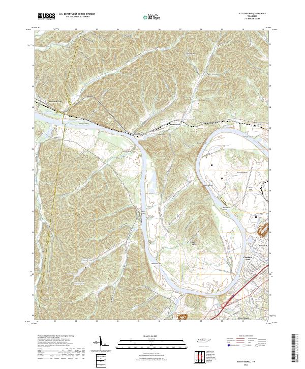
2022 Map of Scottsboro
USGS Topo · Published 2022About this map
The Cumberland River meanders through this portion of Davidson County, carving deep oxbows like Whites Bend and Cockrill Bend. This modern survey illustrates the proximity of the western Nashville suburbs to the steep, wooded hollows of the Highland Rim. Developed residential areas like Charlotte Park and West Meade in the southeast contrast sharply with the topographical complexity of the northern hills around Turnover Hill and Potato Hill. The river remains the primary geographic anchor, home to prominent features such as Robertson Island and Gower Island. Aviation is well-represented by the presence of both the John C Tune Airport near the metropolitan edge and the Oakley Airport further west. Local infrastructure is defined by a network of winding valley roads like Old Hickory Blvd and Hydes Ferry Pike, which follow the natural contours of the drainages including Sulphur Creek and Bull Run.
Find a feature on this map
115 named features on this map. Tap any name to fly to it.
Don’t see what you’re looking for? This feature index may not catch every label — zoom into the map to look around manually.
Map Details
Editions of this 2022 Scottsboro Map
This is the sole edition of this map. No revisions or reprints were ever made.
Other maps of this area

1903 · Nashville
USGS Topo · 1:125,000

1930 · White Bluff
USGS Topo · 1:62,500

1931 · Ridgetop
USGS Topo · 1:62,500

1932 · Nashville
USGS Topo · 1:62,500

1933 · White Bluff
USGS Topo · 1:62,500

1935 · Ridgetop
USGS Topo · 1:62,500

1952 · Nashville West
USGS Topo · 1:24,000
1953 · Oak Hill
USGS Topo · 1:24,000

1955 · Whites Creek
USGS Topo · 1:24,000

1955 · Forest Grove
USGS Topo · 1:24,000